Mount Curtis Gilbert via Klickton Divide
We parked at the Conrad Meadows trailhead. We met with a lot of cows
on the trail through Conrad Meadows, and the trail appeared to be
heavily used by horses. The only person we encountered on the whole
trip was a hunter and his horse in Conrad Meadows. The alder in
Conrad Meadows were in their full fall color, the larch were just
starting to turn.
Half a dozen switchbacks after passing Surprise Lake we took a
bootpath to the left that passed through a campsite, followed a
small creek for a hundred feet, and then faded away soon after. (We
didn't find the bootpath marked by two cairns that was described in 75
Scrambles, maybe that was further down trail 1120.) We continued up
the slope of the Klickton Divide until we reached a spot where it
leveled out (not the top) around 6,200 feet, then we contoured NW to
Warm Lake.
We made camp on the west side of Warm Lake. This was one of the best
campsites I've stayed in, there were impressive cliffs to the NW, good
exposure to the morning sun, a lovely lake, solitude, and there were
even some rocks just a hundred feet to the west that looked like
they would make for excellent bouldering.
The next morning the route from Warm Lake to the summit was
straightforward. We headed SW up the face of the Klickton Divide,
then followed a bootpath at the top of the ridge to the summit block.
A bit of rock scrambling near the base of the west side of the buttress
brought us to the summit.
We made our return from Warm Lake a loop by following the meadows the
creek from Warm Lake runs through until we reached point 6290. We
went east of point 6290 and found a nice bootpath at 6,100 feet. We
followed the bootpath north, and then NNE until we hit a trail running
up from the valley, we went right on the trail and descended to trail
#1120, and followed trail #1120 clockwise until it returned us to the
trail #1120 loop intersection.
Date:
2004/10/04
to 2004/10/05
Elevation gain:
4,220 feet
Car-to-car:
2 days
-
4 hours 15 minutes
driving
from
Vancouver, WA
to
Conrad Meadows trailhead
-
1 hour 31 minutes
ascending
from
Conrad Meadows trailhead
to
trail #1120 loop intersection
-
1 hour 7 minutes
ascending
from
trail #1120 loop intersection
to
Surprise Lake
-
19 minutes
ascending
from
Surprise Lake
to
bootpath
-
1 hour 14 minutes
ascending
from
bootpath
to
Warm Lake (camp)
-
2 hours 1 minute
ascending
from
Warm Lake (camp)
to
Mount Curtis Gilbert
-
1 hour 24 minutes
descending
from
Mount Curtis Gilbert
to
Warm Lake (camp)
-
1 hour 6 minutes
descending
from
Warm Lake (camp)
to
intersection of old trail and trail #1120
-
1 hour 9 minutes
descending
from
intersection of old trail and trail #1120
to
trail #1120 loop intersection
-
1 hour 45 minutes
descending
from
trail #1120 loop intersection
to
Conrad Meadows trailhead
.jpg)
Meadow below Warm Lake (near Mount Curtis Gilbert)
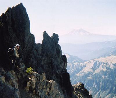
Buttress below summit of Mount Curtis Gilbert
Copyright © 2024 Gabriel Deal.