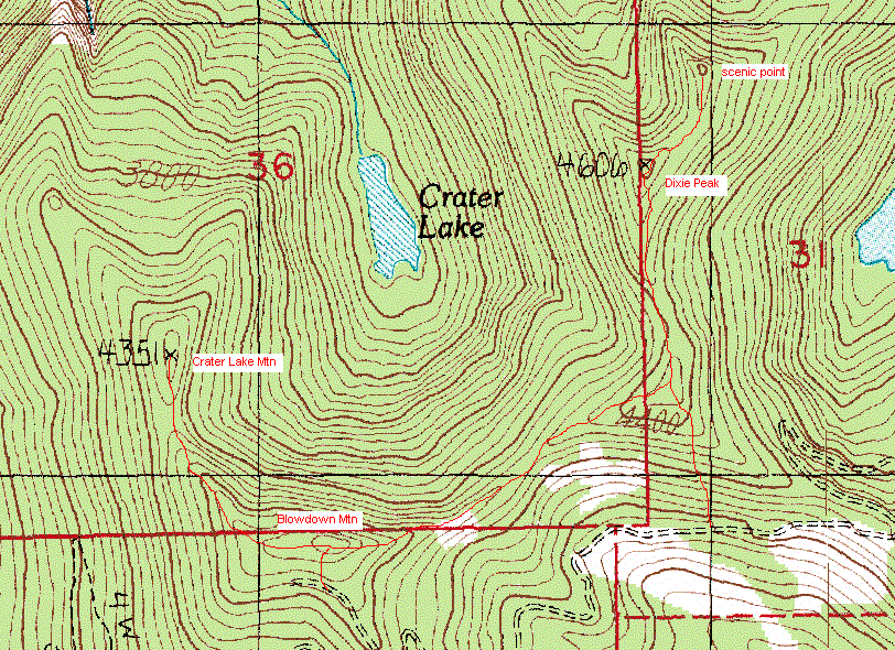
Dixie Peak and Blowdown Mountain via logging roads
I parked at the Mount Teneriffe Trailhead and rode my mountain bike up
the Mount Teneriffe Road-Trail to the T-intersection in the road at 3,560'.
Actually I rode up to about 1,200' elevation and then pushed my bike
for the remaining 2,360' vertical feet, it's a steep road.
I stashed my mountain bike at the T-intersection and took the left branch of the
road. Right after the road turns sharply right at 3,860' I took the
short logging road to the left to check out Rocky Butte (point
3,880+). Not a lot to see here, the rocky part of Rocky Butte is only
visible from below.
I then returned to the main road and headed towards Blowdown Mountain
(point 4,560+), which has a logging road that leads to just S of the
summit. I couldn't find any place that was clearly the summit since
it was pretty flat and covered by dense groups of young trees, no view
here.
From Blowdown Mountain I followed the ridge to the NW to Crater Lake
Mountain (point 4,351). Reaching the ridge was a bushwack, pushing
through young trees growing close together and climbing over slick old
blowdowns. But once I passed that short, brushy section the ridge was
easy to travel. Crater Lake Mountain was a partly tree-covered and
partly exposed summit with views of Dixie Mountain to the east.
I returned to Blowdown Mountain and followed the ridge to the east
(more ugly bushwacking) over point 4,440+ and then across the ridge to
the N to Dixie Peak (point 4,606). Dixie Peak is covered by meadows
separated by thick groves of trees. I pushed on to the slightly lower
peak (point 4600+) to the NE of Dixie Peak, this attractive little
peak has 360 degree views including Mount Teneriffe, Mount Rainier, the
North Fork Valley, and the entire Olympic Range. It almost made the
slog and bushwacking worth it to me.
I then returned to point 4,440+ and descended its S face to the
logging road and quickly returned to my bike at the T. The ride down
was gratifyingly swift if not exactly enjoyable (it was mostly
non-stop heavy braking).
Elevation gain:
3,815 feet
Trip type:
mountain bike, scramble, bushwack
In:
Middle Fork Snoqualmie Drainage
Car-to-car:
7 hours 6 minutes
-
18 minutes
driving there
from
Lower Queen Anne
to
I-90 and I-405
-
32 minutes
driving there
from
I-90 and I-405
to
Mount Teneriffe Trailhead
-
1 hour 44 minutes
ascending via bike
from
Mount Teneriffe Trailhead
to
T in road
-
1 hour 12 minutes
ascending
from
T in road
to
Blowdown Mountain
-
20 minutes
ascending
from
Blowdown Mountain
to
Crater Lake Mountain
-
28 minutes
ascending
from
Crater Lake Mountain
to
Blowdown Mountain
-
42 minutes
ascending
from
Blowdown Mountain
to
Dixie Peak
-
10 minutes
ascending
from
Dixie Peak
to
point 4,600'+
-
1 hour 1 minute
descending
from
point 4,600'+
to
T in road
-
32 minutes
descending via bike
from
T in road
to
Mount Teneriffe Trailhead
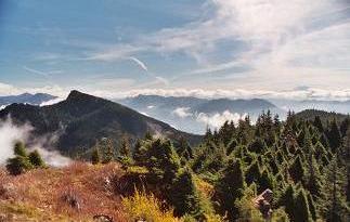
Mount Teneriffe from the small peak NE of Dixie Peak
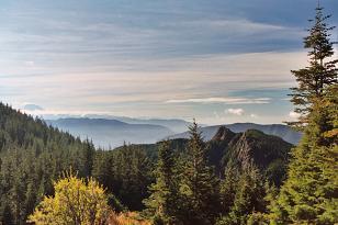
Mount Si from Crater Lake Mountain
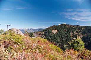
Dixie Peak from Crater Lake Mountain
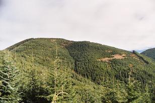
Beautiful Blowdown Mountain from Rocky Butte
Dixie Peak, Blowdown Mountain and Crater Lake Mountain
Copyright © 2026 Gabriel Deal.