Low Mountain via Hemlock Pass
We had to take exit 52 off of I-90 because there was a bridge out
between exit 47 and the Denny Creek trailhead.
Carlos and I were starting late so we took a pretty brisk pace up
trail #1014 to Hemlock Pass. At the pass we left the trail and took
the north ridge of Low Mountain. At first the top of the ridge was
pretty choked with young hemlock trees, we found staying to the east
side of the ridge was a bit less brushy, but eventually the brush on top of the ridge got
better. The last 100 vertical feet of the north ridge (right before
the summit) looked like a climb so we dropped down to the east side of
the ridge and traversed below the rock. My friend soon stopped
because he was uncomfortable on the slope, there wasn't much exposure
but the slope was pretty steep and covered with a crummy, thin layer
of snow that made footing difficult. (At that point we probably
should have dropped down lower and traversed where the slope was more
gradual.) I continued on, traversed below the summit, and came up on
the south ridge. From the south ridge the summit block is a walk-up.
If it hadn't been snowy and wet then going up the east side of the
summit block might have been a fun rock scramble.
On my way back from the summit I was glad of my ice axe as I had to
self arrest once before getting to where my friend was waiting. We
returned the same way, again keeping a pretty brisk pace on the trail
to beat the impending sunset (it beat us by 9 minutes).
Elevation gain:
3,245 feet
USGS quad:
Snoqualmie Pass
In:
South Fork Snoqualmie Drainage, Alpine Lakes Wilderness
Car-to-car:
7 hours 12 minutes
-
1 hour 8 minutes
driving there
from
Lower Queen Anne
to
Denny Creek Trailhead
-
1 hour 46 minutes
ascending
from
Denny Creek Trailhead
to
Hemlock Pass
-
1 hour 48 minutes
ascending
from
Hemlock Pass
to
Low Mountain
-
20 minutes
descending
from
Low Mountain
to
ridge right below Low Mountain
-
1 hour 4 minutes
descending
from
ridge right below Low Mountain
to
Hemlock Pass
-
1 hour 24 minutes
descending
from
Hemlock Pass
to
Denny Creek trailhead
-
1 hour 9 minutes
driving back
from
Denny Creek trailhead
to
Lower Queen Anne
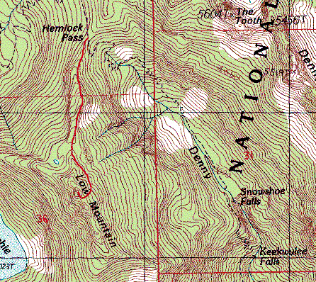
Low Mountain via Hemlock Pass map
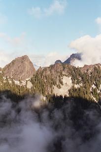
The Tooth from Low Mountain

Summit of Low Mountain from the north ridge
Copyright © 2024 Gabriel Deal.