Fuller Mountain loop
I parked at the North Fork gate 11 intersection and walked down the
road to the west to intersection on the other side of gate 10. At the
intersection there was a sign marking the start of the Ten Creek loop
trail, I followed this trail. Just before crossing Ten Creek the
trail forks, down the wood steps to the left is the return part of the
Ten Creek loop trail (I took this on the way back, it was overgrown
and faint but still followable). I headed straight ahead and crossed
Ten Creek on some tippy logs with chicken wire on top of them. The
trail continued on NW, crossed a logging road (there was a cairn
here), and continued on the other side of the logging road through the
woods to the lower part of a huge borrow pit at the south base of
Fuller Mountain.
I couldn't find where the trail continued after the borrow pit, so I
went up the borrow pit to the upper NW corner and followed an
overgrown logging road to the west side of the broad south ridge of
Fuller Mountain. Here I headed straight up the south slope of Fuller
Mountain following the surveyor's tape and occasionally taking what
appeared to be shadows of an abandoned trail. The woods were open
and the underbrush was rarely above my knees.
When I reached the summit I found the trail and followed it east
through an open meadow of sword ferns and old alder to a rocky
outcropping that overlooks North Bend, Mount Si, and Rattlesnake
Mountain. I sat there in the rain, listened to the logging trucks,
and watched the sun shine on Rattlesnake Mountain for a while before
heading down.
On the way down I followed the trail. From the rocky outcropping, the
trail headed to the east side of the summit, descended via the NW
ridge for a while, switchbacked down the west side of Fuller Mountain,
and finally headed south to near the borrow pit. The trail came out
on the upper fork of the logging road that leads to the borrow pit (on
the map it looks like only the upper fork goes to the borrow pit, but
in reality the lower fork also reaches the pit), there was some pink
surveyor's tape across the logging road from where the trail met the
road. I returned to the borrow pit and took the Ten Creek trail back.
In:
North Fork Snoqualmie Drainage
Car-to-car:
2 hours 22 minutes
-
19 minutes
driving
from
Lower Queen Anne
to
I-90 exit 31
-
40 minutes
driving
from
I-90 exit 31
to
North Fork gate 11
-
1 hour 4 minutes
ascending
from
North Fork gate 11
to
Fuller Mountain
-
1 hour 1 minute
descending
from
Fuller Mountain
to
North Fork gate 11
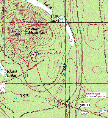
Fuller Mountain map
Copyright © 2026 Gabriel Deal.