Choirboy via CCC Road-Trail
I parked at the Mount Teneriffe Trailhead and rode my mountain bike to
the CCC Road-Trail.
The CCC Road-Trail has developed a new creek crossing since I was
there last, near the east ridge of Green Mountain a creek that I think
used to run under the road has washed the road out. This was the
first of at least three creeks that I had to hop across on rocks or
ford, if the water had been much higher they would have turned me
back.
The old Mount Si Greentrails map I have shows the planned extension to
the CCC Road-Trail, it is incorrect. At a Y the trail goes right
(downhill) and joins the North Fork Road for a short distance before
forking left (well marked with a wooden sign) onto the newest part of
the road-trail. The new upper segment of the road-trail is beautiful
single-track, a joy to ride. But one segment of the new road-trail has
collapsed (it was built on clay) and although the new segment of the
CCC Road-Trail has many nice wooden bridges, there was one big creek
crossing that I had to ford.
The upper end of the CCC Road-Trail ends at the North Fork Road right
across from the Middle Fork trailhead.
From the Middle Fork trailhead I crossed the bridge over the Middle
Fork Snoqualmie River, took the trail to the right for 15 feet or so,
and then headed directly up to the top of the west ridge of Choirboy.
At the top of the ridge there is a boot path marked by flagging. The
boot path climbed steeply up Choirboy almost to the top. After the
boot path petered out I waded through waist-high salal and followed
intermittent paths to the east side of Choirboy where I found the best
views. The views of Garfield Mountain alone made the trip worth it,
awesome! Also visible were Preacher Mountain, Green Ridge, and the
Middle Fork valley to the north and south.
There are pines on top of Choirboy, I don't remember seeing pines
before in the Middle Fork area.
In order to make it back before dark I cut off some time by
riding the Middle Fork Road to the Bessemer CCC Road-Trail Trailhead,
and then took the Bessemer Road Connector Trail to the CCC Road-Trail.
Round-trip distance:
26 miles (3 miles on foot, 23 miles on bike)
Elevation gain:
1,240 feet
In:
Middle Fork Snoqualmie Drainage
Car-to-car:
8 hours 8 minutes
-
49 minutes
driving
from
Lower Queen Anne
to
Mount Teneriffe Trailhead
-
2 hours 26 minutes
ascending via bicycle
from
Mount Teneriffe Trailhead
to
intersection of CCC Road-Trail and Middle Fork Road
-
52 minutes
ascending via bicycle
from
intersection of CCC Road-Trail and Middle Fork Road
to
Middle Fork trailhead
-
1 hour 5 minutes
ascending
from
Middle Fork trailhead
to
Choirboy
-
29 minutes
ascending
from
Choirboy
to
east end of Choirboy
-
1 hour 2 minutes
descending
from
east end of Choirboy
to
Middle Fork trailhead
-
27 minutes
descending via bicycle
from
Middle Fork trailhead
to
Bessemer CCC Road-Trail Trailhead
-
1 hour 28 minutes
descending via bicycle
from
Bessemer CCC Road-Trail Trailhead
to
Mount Teneriffe Trailhead
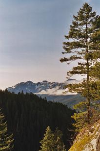
South Middle Fork Valley from Choirboy
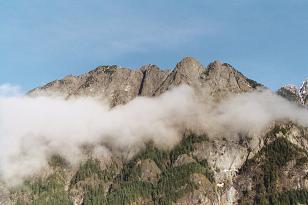
Garfield Mountain from Choirboy
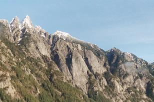
Garfield Mountain from Choirboy
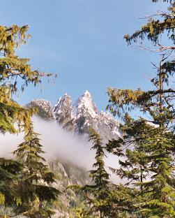
Garfield Mountain from Choirboy
Copyright © 2024 Gabriel Deal.