North Ridge of Mailbox Peak
Carla, Laurie, and I parked at the Mailbox Peak trailhead and walked a
short distance up the Middle Fork Road to the Granite Creek
Road-Trail. After 2.4 miles on the Granite Creek Road-Trail we
started ascending the north ridge of Mailbox Peak where the road
curves to the right around the ridge. Most of the lower part of the
ridge was a mess of blowdowns. Around 4,200' the ridge became choked
with young trees and huckleberry bushes, we had to fight the forest
for the next 500 vertical feet. Finally the ridge cleared off for a
short section of nice scrambling to the summit of Mailbox Peak.
We descended via the trail.
Round-trip distance:
7 miles
Elevation gain:
4,065 feet
Trip type:
bushwack/scramble
USGS quad:
Chester Morse Lake
In:
Middle Fork Snoqualmie Drainage, South Fork Snoqualmie Drainage
Car-to-car:
6 hours 51 minutes
-
1 hour 5 minutes
ascending
from
Mailbox Peak trailhead
to
intersection of Granite Creek Road-Trail and north ridge
-
3 hours 28 minutes
ascending
from
intersection of Granite Creek Road-Trail and north ridge
to
summit of Mailbox Peak
-
1 hour 44 minutes
descending
from
summit of Mailbox Peak
to
Mailbox Peak trailhead
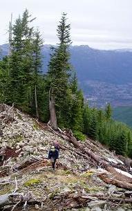
North Ridge of Mailbox Peak at 4,700'
Copyright © 2026 Gabriel Deal.