Pratt Mountain via Olallie Lake
Ian and I parked at the trailhead for Pratt Lake and Granite Mountain
and headed up the trail towards Olallie Lake. At the pass between
Pratt Mountain and point 5566 (West Granite Mountain) we headed NW up
the ridge to Pratt Mountain. The ridge was pleasant, just a little
brushy, with some large granite boulders that could be scrambled in
dry weather or easily avoided otherwise. The last couple hundred feet
of the ridge before the summit was a boulder field, which was very
unpleasant with only 6 inches of snow.
On the descent we went down the SW side of the mountain, right across
another nasty, slippery boulder field which eventually led us to the
pleasant meadow land east of Rainbow Lake. We met the trail here and
followed it back to the trailhead.
The slick boulder fields were the only difficulties. This trip would
be best either in dry conditions or when there is a good snowpack to
cover the boulder fields.
Round-trip distance:
12 miles
Elevation gain:
3,390 feet
USGS quads:
Bandera, Snoqualmie Pass
In:
Middle Fork Snoqualmie Drainage, South Fork Snoqualmie Drainage
Car-to-car:
6 hours 57 minutes
-
13 minutes
driving
from
Lower Queen Anne
to
Mercer Island Park and Ride
-
40 minutes
driving
from
Mercer Island Park and Ride
to
Pratt Lake trailhead
-
3 hours 32 minutes
ascending
from
Pratt Lake trailhead
to
summit of Pratt Mountain
-
3 hours 4 minutes
descending
from
summit of Pratt Mountain
to
Pratt Lake trailhead
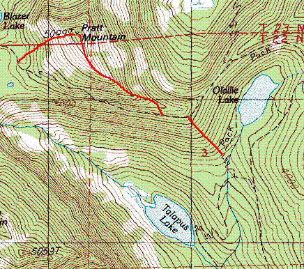
Pratt Mountain map
Copyright © 2024 Gabriel Deal.