Teanaway Butte via Jungle Creek Road
Atsuko and I parked at 29 Pines Campground, the road was plowed up to
here. We donned our skis and headed up Jungle Creek Road, at the
3-way intersection, shortly after crossing the North Fork Teanaway
River, is a sign stating that Jungle Creek Road is for non-motorized
users only. We saw no snowmobiles tracks after this point.
The trail was only broken for a quarter mile, after that we had a
long, long slog on untracked snow up the very moderate Jungle Creek
Road to Liars Prairie (east of the butte). Once we were east of
Teanaway Butte, we headed straight up it, making it to the summit with
no difficulties.
The summit of Teanaway Butte has close to a 360 degree view. The
Stuart Range is in sight and so is much of the Teanaway. It has a
great view.
Teanaway Butte itself was a great winter summit, but the long approach
on the road was pretty dull, no views, and most of the time it's not
even steep enough to glide down on skis without pushing off.
Elevation gain:
2,140 feet
Trip type:
backcountry ski
USGS quad:
Teanaway Butte
Car-to-car:
8 hours 31 minutes
-
1 hour 53 minutes
driving there
from
65th St Park and Ride
to
29 Pines Campground
-
5 hours 31 minutes
ascending
from
29 Pines Campground
to
summit of Teanaway Butte
-
2 hours 28 minutes
descending
from
summit of Teanaway Butte
to
29 Pines Campground
-
2 hours 7 minutes
driving back
from
29 Pines Campground
to
65th St Park and Ride
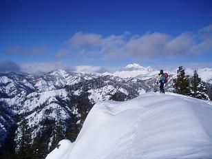
The Teanaway from Teanaway Butte (Mount Stuart in the background)
Copyright © 2024 Gabriel Deal.