Web Mountain via Dirty Harry's road-trail
We parked at the trailhead for Dirty Harry's Peak, on the north side
of Exit 38, and headed up the paved road that leads to a fire training
area. After less than a mile we headed right up Dirty Harry's
road-trail. Around 3,500' the trail fork at the bottom of a talus
field, the route to Dirty Harry's Peak goes left and our route was
straight ahead. The trail contoured below the talus field as it
headed ENE toward a small tarn at 4,353', Greentrails maps show this
trail to the tarn.
From the tarn we followed a flagged path ESE up the basin that is west
of Web Mountain. Because of snow on the north side of the ridge, we
stayed in the basin instead of taking the ridge and ascended on a
talus field to the summit.
This was a surprisingly brush-free and aesthetic route. For an
after-hours trip it was fairly ambitious, we got back to the cars at
11:30 PM.
Date:
2006/06/07
to 2006/06/08
Elevation gain:
4,060 feet
In:
South Fork Snoqualmie Drainage, Middle Fork Snoqualmie Drainage
Car-to-car:
6 hours 12 minutes
-
2 hours 56 minutes
ascending
from
Dirty Harry's trailhead
to
summit of Web Mountain
-
2 hours 50 minutes
descending
from
summit of Web Mountain
to
Dirty Harry's trailhead
-
49 minutes
driving back
from
Dirty Harry's trailhead
to
Lower Queen Anne
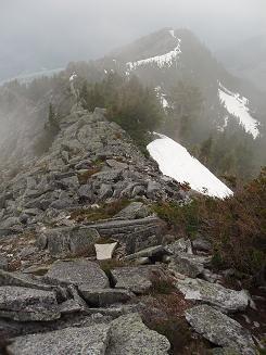
SW ridge of Web Mountain from summit
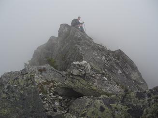
Summit of Web Mountain
Copyright © 2026 Gabriel Deal.