Sloan Peak via Corkscrew Route
This was one of the stand-out trips of my year so far, it's hard to
imagine how it could have gone more smoothly or perfectly.
Carla, Brian, and I parked at the "Sloan Peak Climbers Rte." sign at
the Cougar Creek trailhead (trail #648). We followed a bootpath to
the North Fork Sauk, encountering a surprising amount of flagging on
the way. Apparently the Sauk can be a major obstacle at some times of
the year, but it was barely knee high for us.
Past the Sauk the trail has its share of blowdowns, and some brushy
sections where we couldn't even see our waists -- much less our feet.
But overall, it was a fine, shaded trail through old forest, it went
quickly. Soon we were at a beautiful, meadowed basin at 4,800'. From
the basin we followed a bootpath SE up the broad gully, when the
bootpath petered out we followed snow and rock slopes to a point on
the ridge above the 5,800' col. Here we got our first view of the
glacier.
We chose to start a bit low on the glacier, starting well below the
two ledges on the NW side of the glacier. As we roped up we heard a
large whoomph collapsing sound from the glacier, a sound we were
to hear a couple more times, fortunately never too close. We worked
our way SW up the glacier, zigzagging around crevasses, and crossing a
couple snow bridges to the SW corner.
At the SW corner we dropped the glacier gear and followed the
well-defined climber's path running along a ledge on the south side of
the summit. At times it is narrow and exposed. At the SW corner the
path turned up a gully full of loose rock. From here it was a
scramble to the summit, with a few climbing moves.
On the descent we stayed high on the glacier, which was much more
direct and avoided most crevasses. We exited onto the upper of the
two ledges that protrude into the glacier. From here it was an
enjoyable class 2 rock scramble back to the 5,800' pass.
On the way back I enjoyed a quick dip in the Sauk. Cold!
Elevation gain:
5,800 feet
Trip type:
basic alpine climb
Car-to-car:
11 hours 54 minutes
-
4 hours 35 minutes
ascending
from
Cougar Creek trailhead
to
north edge of the Sloan Glacier
-
54 minutes
ascending
from
north edge of the Sloan Glacier
to
SW corner of the Sloan Glacier
-
53 minutes
ascending
from
SW corner of the Sloan Glacier
to
summit of Sloan Peak
-
33 minutes
descending
from
summit of Sloan Peak
to
SW corner of the Sloan Glacier
-
45 minutes
descending
from
SW corner of the Sloan Glacier
to
NW corner of the Sloan Glacier
-
41 minutes
descending
from
NW corner of the Sloan Glacier
to
5,800' pass N of glacier
-
2 hours 35 minutes
descending
from
5,800' pass N of glacier
to
Cougar Creek trailhead
-
2 hours 26 minutes
driving back (via Darrington)
from
Cougar Creek trailhead
to
Capitol Hill
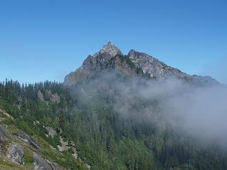
SE side of Bedal Peak
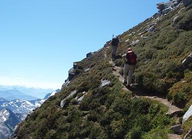
Climber's path on S side of Sloan Peak above the glacier
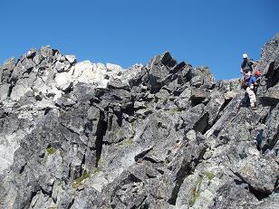
Summit block of Sloan Peak
Copyright © 2024 Gabriel Deal.