Mailbox Peak and Dirtybox Peak
Carla, Laurie, Logan (the dog), and I parked at the Mailbox Peak
trailhead and headed up the trail to Mailbox Peak. At the summit of
Mailbox Peak, we pushed on to our primary destination, point 4926,
which I have dubbed Dirtybox Peak. Dirtybox is the peak between
Mailbox Peak and Dirty Harry's Peak, it is taller than Mailbox and
Dirty Harry's. It seems odd to me that it doesn't gave a name, given
the popularity of the two lesser peaks that surround it.
We found it easiest to stay on the south side of the ridge, sometimes
dropping down 50 feet or so to bypass rocky sections. At one point we
hit a short class 3 section where Logan had to jump into a tree to get
through, I wish I had seen that. Other than that section, it was all
straight-forward class 2 to the summit.
The summit was a high point on a narrow, treed ridge, with a cairn on
top of a boulder.
On the way back we bypassed the summit of Mailbox Peak by traversing
the south side of the to regain the trail on the west ridge.
Elevation gain:
4,180 feet
USGS quad:
Chester Morse Lake
In:
Middle Fork Snoqualmie Drainage, South Fork Snoqualmie Drainage
Car-to-car:
6 hours 57 minutes
-
41 minutes
driving there
from
Capitol Hill
to
Mailbox Peak traillhead
-
2 hours 46 minutes
ascending
from
Mailbox Peak traillhead
to
summit of Mailbox Peak
-
23 minutes
ascending
from
summit of Mailbox Peak
to
summit of Mailbox Peak
-
2 hours 41 minutes
descending
from
summit of Point 4926
to
Mailbox Peak traillhead
-
43 minutes
driving back
from
Mailbox Peak traillhead
to
Capitol Hill
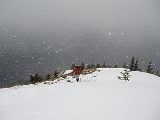
West ridge of Mailbox Peak
Copyright © 2026 Gabriel Deal.