Avalanche Mountain via Snow Lake trail (attempted)
I parked at Alpental and took trail 1013 (Snow Lake trail) to the pass
just south of Snow Lake. At the pass I left the trail and followed a
bootpath east on the ridge. I was planning to go to point 5,200+ on
the ridge and then go north on another ridge to Avalanche Mountain.
But at around 4,975' the ridge became very rocky and steep so I
turned around. (Maybe I could have contoured below it, at the time
the rainy and foggy conditions didn't let me see low enough to tell.)
On to plan B.
I returned to the trail at the pass and followed the trail to the low,
broad ridge that runs east from Snow Lake to Avalanche Mountain. I
pushed through tolerable amounts of huckleberry bushes on this ridge
until I reached the base of Avalanche Mountain. Inexplicably, I
turned around here and took the ridge back to Snow Lake.
On the way home I took the Source Lake loop trail, it has great views
of Bryant Peak, The Tooth, and friends.
Elevation gain:
2,260 feet
USGS quad:
Snoqualmie Pass
In:
Middle Fork Snoqualmie Drainage, Alpine Lakes Wilderness
Car-to-car:
6 hours 27 minutes
-
5 minutes
driving there
from
Lower Queen Anne
to
Larry's Market
-
15 minutes
driving there
from
Larry's Market
to
I-90 and I-405
-
43 minutes
driving there
from
I-90 and I-405
to
Snow Lake trailhead (Alpental)
-
1 hour 2 minutes
ascending
from
Snow Lake trailhead (Alpental)
to
pass S of Snow Lake
-
54 minutes
ascending
from
pass S of Snow Lake
to
unpassable section of ridge
-
20 minutes
ascending
from
unpassable section of ridge
to
pass S of Snow Lake
-
27 minutes
ascending
from
pass S of Snow Lake
to
turn off trail onto flat ridge E of Snow Lake
-
39 minutes
ascending
from
turn off trail onto flat ridge E of Snow Lake
to
base of Avalanche Mountain
-
49 minutes
descending
from
base of Avalanche Mountain
to
turn off trail onto flat ridge E of Snow Lake
-
1 hour 37 minutes
descending
from
turn off trail onto flat ridge E of Snow Lake
to
Snow Lake trailhead (Alpental)
-
57 minutes
driving back
from
Snow Lake trailhead (Alpental)
to
Lower Queen Anne
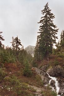
Avalanche Mountain, just visible from Snow Lake trail
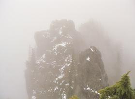
Impassable section of ridge east of trail
Copyright © 2026 Gabriel Deal.