Little Saint Helens from Carter Creek
Ian and I parked on Road 55 next to the bridge over Carter Creek. We
hiked through the open second growth forest on the east side of Carter
Creek to Carter Creek Camp on the John Wayne Pioneer Trail. The
"backcountry campground" even has its own nice, new outhouse.
From the campground we continued up the slope heading SSE through much
younger forest. This went on for about a thousand vertical feet, it
wasn't horribly brushy though, I had skis strapped to my pack and made
it through without much frustration. Finally we hit the logging road
that contours around the north slopes of Little Saint Helens around
3,400'.
We followed the road east until the trees above thinned out a bit
between the two broad ridges that run north from Little Saint Helens.
We regained the western-most of the ridges around 3,600' and followed
it to the summit.
From 3,600' on it was open slopes. Actually, it was logged out all
the way to the summit and there were many young trees but they were
mostly buried in the snow. I wonder how long ago this was logged out?
At 4,000' I imagine the forest regrows very slowly. It made for great
for skiing.
Elevation gain:
3,100 feet
Trip type:
scramble/backcountry ski
USGS quads:
Findley Lake, Bandera
In:
South Fork Snoqualmie Drainage
Car-to-car:
7 hours 3 minutes
-
4 hours 36 minutes
ascending
from
Carter Creek and Road 55
to
summit of Little Saint Helens
-
2 hours 1 minute
descending
from
summit of Little Saint Helens
to
Carter Creek and Road 55
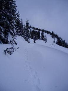
Ascending the N side of Little Saint Helens
Copyright © 2026 Gabriel Deal.